


Storms
Description
This section is from "The American Cyclopaedia", by George Ripley And Charles A. Dana. Also available from Amazon: The New American Cyclopædia. 16 volumes complete..
Storms
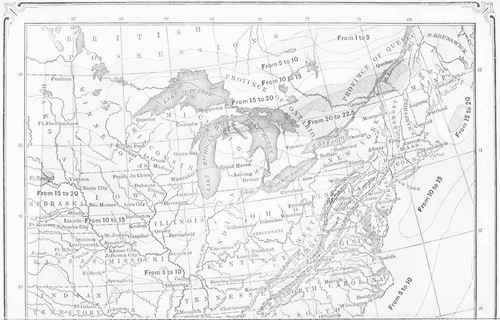
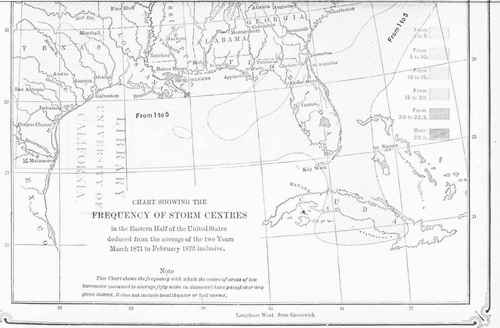
Storms, violent atmospheric disturbances. (See Wind.) Storm areas are in general characterized by low barometric pressure at their centres; winds increasing in force toward the central region, and by their directions showing the lower portion of the atmosphere to bo moving spirally in, toward and around the centre; heavy masses of low clouds attended by a higher stratum that moves around and out from the centre; rain or snow falling especially on the advancing side or front of the storm; temperatures above the average in front, and below the average in the rear of the storm. The storm area with its attending features moves bodily along the earth's surface for several days. A map showing the average number of centres of storms that pass over the eastern portions of the United States is published in the "Statistical Atlas" of the census bureau (1875), and is here reproduced.
The number of storm centres passing over any region increases as we go from the lower latitudes toward Hudson bay, being greatest in the region of the St. Lawrence valley and the great lakes. This arises from the fact that while on the one hand many storms move eastward along the northern limits of our field of observation, on the other hand the storms that originate in the lower latitudes tend to move northward. Nine tenths of the storm tracks on which this map is based have moved toward and over New England and Lower Canada. The chart also shows in Nebraska a region of specially numerous storm tracks, from the fact that the storms coming both from Texas and from Dakota frequently move respectively N. E. and S. E. toward this region; and frequently we find here also the first trace of a class of storms that appear to originate on the spot. The peculiarities in the distribution of storms are apparently fully explained by the- topography of the continent. When we consider that at any station in the northern hemisphere the winds veer from S. E. to S. W. and N. W. as a storm centre passes N. of it, we perceive from this map that throughout the United States E. of the Rocky mountains the veering of the wind will be more frequent than its backing, in the proportions indicated by the relative number of storm centres that pass to the north and south of the station.
For the ocean, it has in general not yet been possible to compile any general map of the average paths of the storms; but from the logs of vessels a great mass of information relative to the frequency of gales and stormy winds has been compiled, and this information is very nearly related to that given by the accompanying chart. The first map of this kind was compiled at the United States naval observatory by M. F. Maury; and the work of collecting such data has been actively pursued by the meteorological officers of all nations, especially England and Holland. - Within 20° of the equator storm winds are exceedingly rare, but their number increases rapidly as we approach the latitude of 50° N. or S. During our northern summer the percentage of stormi-ness diminishes in the North Atlantic and increases in the South Atlantic ocean. In either hemisphere, winter is its stormy season. Within the limits of our observations, viz., up to the parallel of 40° on either side of the equator and in mid-ocean, the southern winter is sensibly as stormy as the northern; but beyond these parallels, and especially near the coast of North and South America, the northern hemisphere is far more stormy than the southern; the probable cause is the greater mass of dry land, and consequently of dry cold air, contiguous to the North Atlantic, as compared with the little land bordering the South Atlantic. Among the regions most frequently passed over by vessels of all nations, the neighborhoods of Cape Horn and the cape of Good Hope are next in importance to the great highway between Europe and America. The charts of the ocean in the neighborhood of Cape Horn, published by the London meteorological office (1871), do not give the percentages of storms; but for the cape of Good Hope, the charts of Cornelissen (1874), of the meteorological institute of the Netherlands, show that during the southern summer the storms in this region are comparatively few and feeble.
In winter severe westerly gales are exceedingly abundant to the south of the cape. In the immediate neighborhood of the continent, and on either side, the influence of the land is shown in the frequency of storm winds blowing off shore during winter, and on shore during summer. - Storm Warnings. Suggestions for storm warnings were broached even in the 18th century, before the introduction of the electric telegraph had rendered the undertaking practicable. The Europeans were the first to engage systematically in storm warning; but in the early demonstration of the feasibility of the idea, the merchants and the individual meteorologists of the United States took the lead. If we pass by that which Franklin, Espy, Bache, Redfield, Loomis, Maury, and others did to advance our knowledge of atmospheric phenomena, and consider merely the steps taken to establish national systems of storm warnings, we shall note that in 1835 the joint meteorological committee of the Franklin institute and the American philosophical society at Philadelphia appointed, at the suggestion of Bache and Espy, a sub-committee to memorialize congress upon the subject of a national weather bureau for the study and prediction of storms.
When the success of the Morse telegraph was beyond all question, Redfield in 1840, and Loomis in 1847, urged its systematic application to the problem in hand. This idea was greatly furthered by Prof. Joseph Henry, who as secretary of the Smithsonian institution had just removed to Washington. In 1847, in behalf of that institution, he organized a system of volunteer meteorological observations and reports. Through the liberality of the National telegraph line, Prof. Henry was in 1857 able to begin the publication of a telegraphic weather bulletin, and to make successful weather predictions. Meanwhile, the appointment of Espy as meteorologist successively to the war and navy departments, and the publication (1850 and 1857) of his famous reports on meteorology, had awakened a universal conviction that storm predictions were practicable. Already many merchants were habitually obtaining at their own expense weather reports from distant sections. The Smithsonian weather bulletin was of necessity discontinued in 1861, and an effort to revive it in 1864 was frustrated only by a conflagration which destroyed a portion of the Smithsonian building early in the following year.
It does not appear that anything more was done in America in the prosecution of the subject of weather predictions until in 1868, in his inaugural report as director of the Cincinnati observatory, the writer proposed this as a work proper for one branch of the institution which he proposed to build up in that city. A few months after this date the Cincinnati chamber of commerce authorized him to obtain at its expense, for three months, the necessary telegrams, and to publish daily weather predictions. This system went into operation on Sept. 1, 1869. In a modified form, and pending further negotiations, the work was continued at the joint expense of the writer and the Western Union telegraph company from December, 1869, to May, 1870, and afterward entirely at the expense of that company, whose manifold weather maps were in much demand until the commencement in November, 1870, of the great work of the army signal office. (See Signal Service.) - Simultaneously with the spread of the telegraph in Europe began the publication of weather bulletins, and their collation and study.
Kamtz says that even in 1835 he had begun to study the weather reports in the Berlin papers, but it required the excitement of the Crimean war, in 1854, to force the importance of the subject upon the attention of European governments. In that year Leverrier as director of the Paris observatory took up the subject; his telegraphic reports began in 1855, and his international bulletin in 1858. Weather probabilities were not begun till 1863; these were discontinued in 1865, and only lately have been revived, but storm warning signals have been uninterruptedly displayed since 1860. In 1861 Admiral Fitzroy, of the meteorological department of the board of trade, began the display of storm signals in England, and in the latter part of the year the publication of weather forecasts; his system of warnings consisted rather of a series of signals announcing the presence of storms, than of any real prediction of their advent. The Fitzroy system ceased in 1866, shortly after his death, but was renewed in 1867. Since that time the British ports have regularly received storm warnings, but the display of the storm signal and storm drum was only revived in March, 1875. The French and English systems of storm warnings were in. some respects preceded by the system organized in Holland by Buys-Ballot, who in 1854 had announced his famous rule for that conn-try in regard to the direction of the wind, as depending on barometric disturbance.
In 1860 he began the communication to the shipping ports of storm warning despatches, and was in fact by his signals the first to utilize the despatches contained in the telegraphic weather bulletins of Leverrier. The organization of the French, English, and Dutch systems suffices to furnish for other European nations such storm predictions as are needed for their respective ports. Thus Spain, Italy, Sweden, Hanover, Russia, Austria, and Turkey receive regularly from Paris and London announcements of the condition of the weather, especially of impending storms. Every nation of the civilized world, including China and Japan, now has national offices for collecting and utilizing meteorological observations. As a general rule, the warning signal, whether it be the drum or cone as in England, or the flags and lights adopted in other countries, is intended to announce merely that the chances are that there will soon be a dangerous high wind in the neighborhood of the station.
Continue to:


My Books

